How to get around
Getting to the Savio Valley
The Savio Valley is located in Emilia-Romagna within the provinces of Forlì-Cesena, Ravenna and Rimini. It runs for about 120 km, along the course of the river Savio, from the mountains of the Tuscan-Romagna Apennines to the shores of the Adriatic Sea.
The Unione dei Comuni Valle Savio is mainly located in the Savio Valley, from Verghereto, where the river rises, to Cesena, capital of the province.
Depending on the means by which you wish to travel, there are various ways of accessing the Valley, by car, train, bus and plane.
Find here all the information on how to get to and how to get around the Valley.
How to get here
By car
The gateway to the Valley, coming from Romagna (north), is the city of Cesena, accessible via the A14 motorway (Bologna – Taranto) and the European road E55-E45 (Venice – Rome).
This descends towards the valley following the river Savio as far as Verghereto, the gateway when coming from Tuscany (south).
By plane
The nearest airport is Luigi Ridolfi (FRL) in Forlì.
It is 17 km from Cesena.
It is served by the Start Romagna Line 7 and the railway line, and is connected:
- to the A14 motorway;
- to the state road 3 bis;
- to the Forlì ring road;
- to state road 9 (via Emilia).
Other airports in easy reach of the Valley are the Rimini International Airport (RMI) and the San Marino “Federico Fellini”, 40 km from Cesena, and the Bologna G. Marconi Airport (BLQ), 90 km from Cesena.
By bus
To reach the Valley by bus there are two connection services:
- Start Romagna if arriving from Romagna, destination station Cesena
- Sulga if arriving from Tuscany, the easiest stations are Arezzo or Sansepolcro.
How to get around
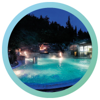
Bagno di Romagna
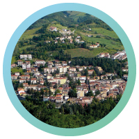
Cesena
Mercato Saraceno
Montiano
Sarsina
Verghereto
Bagno di Romagna
CAR
Bagno di Romagna can be reached by car via the E45, “Bagno di Romagna” exit, or via the Umbro Casentinese Romagnola Regional Road 71, which runs through the municipality.
From north or south: take the A14 motorway and exit at Cesena Nord and then continue on the E/45 towards Rome until you see the signs for “Bagno di Romagna” or “S.Piero in Bagno” (48 km).
From Rome: follow the A1 to Orte and then the E/45 to the “Bagno di Romagna” or “S. Piero in Bagno” exit (km 265).
From Florence: take the Autostrada del Sole motorway to Arezzo, then continue on the SS 73 to Sansepolcro where you take the E/45 (towards Ravenna) to Bagno di Romagna (km 150).
Alternatively, you can opt for the “historic” route: Florence – Pontassieve – Consuma – Bibbiena – Passo dei Mandrioli – Bagno di Romagna (88 km).
TRAIN
By train, the nearest stations are Cesena and Sansepolcro (in Romagna) and Arezzo (in Tuscany). You can then continue with the Start Romagna Line No. 138 Cesena-Bagno di Romagna-Balze.
BIKE
There is a cycle path connecting Bagno di Romagna and San Piero.
BUS
Bagno di Romagna is served by Start Romagna (daily connections) lines 138, 122, 218, 206, 209 and by Sulga (from Rome, Umbria and Tuscany)
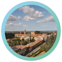
Cesena
CAR
Cesena is located on the A14 motorway (recommended exit for the centre: “Cesena nord”), on the E45 (recommended exit for the centre: Secante and then follow the signs) and on the Via Emilia, the ancient Roman road that still runs through it.
From the north (Bologna): from the A14 Adriatica motorway towards Ancona, take the Cesena Nord exit, continue on the E45 towards Rome, and follow the direction to Cesena on the SS 9 Via Emilia.
From the south (Ancona): from the A14 Adriatica motorway towards Bologna, exit at Cesena.
From Ravenna: take the E45 towards Cesena and continue on the SS 9 Via Emilia.
From Forlì: take the SS 9 Via Emilia towards Forlimpopoli, Cesena.
TRAIN
The Cesena station is well-connected on the Milan-Bologna-Taranto line and has regional, fast regional, intercity and white arrow trains. From 26 may Cesena is a stop on the high-speed train from Munich (Germany).
BUS
Cesena has a well-developed urban and extra-urban transport service provided by Start Romagna, with daily connections to the coast (Rimini, Cesenatico, Cervia), to the Savio Valley (stops in all the main villages), to the main Italian cities (Milan, Bologna, Rome, etc.), and to the main airports (daily connections to Bologna and Rimini). Cesena is served by the Start Romagna line (daily connections) line 138.
BIKE
A cycle path connects Cesena with the Adriatic coast (Cesenatico or Cervia) and continues along the Savio Valley (nearing completion).
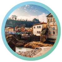
Mercato Saraceno
CAR
From the north (Bologna): from the A14 Adriatica motorway towards Ancona, exit at the Cesena Nord tollbooth, follow the direction to Rome-Ravenna, continue on the SS 3BIS/E45 state road to Rome, exit towards Mercato Saraceno and continue on the SP 138.
From the south (Ancona): from the A14 Adriatica motorway towards Bologna, exit at the Cesena Nord tollbooth, follow the direction for Rome-Ravenna, continue on the SS 3BIS/E45 for Rome, exit towards Mercato Saraceno and continue on the SP 138.
From Ravenna: take the SS 3BIS/E45 towards Rome, exit towards Mercato Saraceno and continue on the SP 138.
From Rimini: take the SS 9 Via Emilia in the direction of Santarcangelo di Romagna, continue along the SP 13, turn onto the SP 11 in the direction of Borghi and take the SP 12 in the direction of Mercato Saraceno.
TRAIN
The nearest railway station is Cesena, about 26 km away, then take line 138 to Mercato Saraceno.
BUS
Mercato Saraceno is served by the Start Romagna line (daily connections) line 138.
Montiano
CAR
From the north (Bologna): from the A14 Adriatica motorway towards Ancona, exit at Cesena Nord, take the E45 towards Rome, exit at Cesena Secante, follow the direction to Cesena by taking the SS 9 Via Emilia and continue towards Montiano.
From the south (Ancona): from the A14 Adriatica motorway towards Bologna, exit at Cesena Nord, take the E45 towards Rome, exit at Cesena Secante, follow the direction to Cesena by taking the SS 9 Via Emilia and continue to Montiano.
From Ravenna: from the E45 towards Rome, exit at Cesena Secante, continue on the SS 9 Via Emilia towards Cesena and follow the signs for Montiano.
From Forlì: take the SS 9 Via Emilia in the direction of Forlimpopoli, Cesena and continue on the SP 115 in the direction of Montiano.
From Rimini: take the SS 9 Via Emilia in the direction of Santarcangelo di Romagna, then Savignano sul Rubicone and Montiano.
TRAIN
The nearest railway station is Cesena, about 11 km away, then take line 261 to Montiano.
BUS
Montiano is served by the Start Romagna line (daily connections) lines 138, CE21, NAVM, S095.
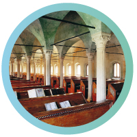
Sarsina
CAR
Sarsina can be reached via the E45, “Sarsina sud” exit, or via the Umbro Casentinese Romagnola Regional Road 71, which runs through the municipality.
From the north (Bologna): take the A14 towards Ancona, exit Cesena nord and take the E45 towards Rome, exit Sarsina.
From the south (Ancona): take the A14 towards Bologna, exit Cesena nord and take the E45 towards Rome, exit Sarsina.
From Rome: take the E45 towards Ravenna, exit Sarsina sud.
TRAIN
The nearest railway station is Cesena, about 30 km away, then take line 138 to Sarsina.
BUS
Sarsina is served by Start Romagna (daily connections) line 138.
Verghereto
CAR
From the north (Bologna) from the A14 Adriatica motorway towards Ancona, exit at the Cesena Nord tollbooth, follow the direction to Rome-Ravenna, continue on the SS 3BIS/E45 state road to Rome and exit towards Verghereto and continue on the SP 137.
From the south (Ancona) from the A14 Adriatica motorway towards Bologna, exit at the Cesena Nord tollbooth, follow the direction for Rome-Ravenna, continue on the SS 3BIS/E45 for Rome and exit towards Verghereto and continue on the SP 137.
From Ravenna:take the SS 3BIS/E45 towards Rome, exit towards Verghereto and continue along the SP 137.
TRAIN
The nearest railway station is Cesena, about 59 km away, then take line 138 to Verghereto.
BUS
Verghereto is served by the Start Romagna line (daily connections) lines 138 and F009 and the Sulga line (from Rome, Umbria, Tuscany).